

Harrisburg Redlined: The Zoning Practices that Segregated a City
Files
Download Full Text
Description
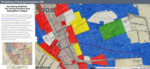
An interactive story map highlighting the unjust practices of racial redlining of Harrisburg in 1935-1936. Map allows the visitors to view the security grading of Harrisburg and its surrounding communities into four grades–“Hazardous,” “Definitely Declining,” “Still Desirable,” and “Best”–according to the character of housing and pouplation.
Publication Date
2025
Document Type
Map
Keywords
Map, redlining, race, systemic racism, Digital Harrisburg, Messiah College, Messiah University, Harrsiburg University of Science and Technology
Disciplines
African American Studies | United States History | Urban Studies and Planning
Recommended Citation
Digital Harrisburg, "Harrisburg Redlined: The Zoning Practices that Segregated a City" (2025). Interactive Maps of Harrisburg. 4.
https://mosaic.messiah.edu/maps/4
Comments
The maps and the data they contain were developed as a collaboration between faculty and students at Messiah University and Harrisburg University of Science and Technology. The Historical Society of Dauphin County generously provided JPEG scans of the entire 1901 Harrisburg Title Company Atlas (the layer visible as the historical map of the city). Messiah students created a complete database of the population in 1900, and GIS students from Messiah and Harrisburg University created building polygons and individual census record points in GIS mapped to the level of individual properties. (For ready-made static maps of the city and its population at different points in time, visit the datasets page)
This item was developed and published in collaboration with the IIPT-Commonwealth Monument Project (2018-2020), with support and funding from Messiah University's Center for Public Humanities and the Council of Independent College's Humanities Research for the Public Good Grant Program.